


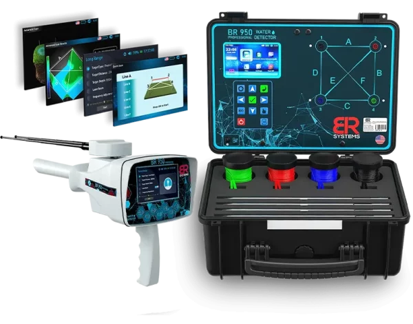
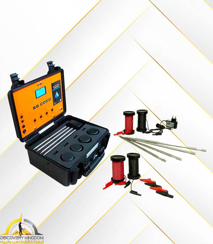
BR 950 Professional
The BR 950 Professional is the latest scientific device specialized in detecting groundwater and underground wells, and is one of the most powerful and accurate devices in this field. Developed using advanced technologies and high-performance search systems, the device is an ideal tool for landowners, farmers, and exploration companies seeking to accurately and easily locate water sources.
The device is characterized by its ability to detect and locate underground water with extreme precision, while determining the depth and optimal drilling point. This contributes to utilizing water resources and alleviating water scarcity problems in various regions.
The BR 950 Professional operates using a dual system that combines soil resistance measurement and a remote sensing system, providing reliable and fast results. It also features a smart, easy-to-use user interface that supports multiple languages to suit different users around the world.
Features of the BR 950 Professional:
-
A specialized device for detecting groundwater and wells.
-
Accurate search systems to determine water locations and depths.
-
Reaches great depths underground.
-
A smart and easy-to-use interface that supports multiple languages.
-
Lightweight, easy to transport, and easy to use.
-
Approved by many exploration companies around the world.
The BR 950 Professional groundwater detector is your ideal choice for searching for underground water accurately and efficiently, making it an indispensable tool for agricultural, development, and land investment projects.
28.000,00 د.إ
BR Systems has for many years been producing groundwater detectors and working on developing and modernizing them to provide the best for its users all over the world, It is flexible in detecting groundwater, and this device has been tested in many regions around the world on a range of different soils and environments, and we have obtained positive results of up to 95%.
BR 950 Professional Specifications
This advanced device is capable of identifying and discovering all types of groundwater and determining the appropriate place for drilling in addition to its ability to separate and distinguish between shallow sedimentary water and deep groundwater, with a percentage showing the detected water thrust with accurate results that exceed the results of similar devices available in the market.
This device was designed and produced after long and deep studies to choose the appropriate mechanical and electronic components that allow the user to move, operate the device and work with it easily and to achieve a high performance and speed in detecting the target by using its modern techniques that achieve the most accurate results in external detection operations within all types of terrain and different climates.
Advanced detection systems: This new detector has been equipped with 4 detection systems that can provide sufficient and accurate information about the locations of water within the explored area, in addition to making a 3D photogrammetric scans showing the location of water in detail and determining its path and knowing the strength and movement of water flow in the discovered place with an indication of the detected water type like fresh, salty or mineral, in a detailed manner and in special proportions that appear on the device screen automatically.
The BR 950 Profissional device is equipped with a modern and easy interface and drivers through which the user can operate the device’s systems and work on them quite easily according to the instructions within the systems, very clear about the methods of operation and the correct connection of the parts of the device and to ensure an accurate result in prospecting operations and avoiding operation and negative conduction.
This device is equipped with an external application installed on a tablet computer, through which we can view the full search results, as well as create a 3D map of the targets and store them directly. The tablet and the device are connected automatically (without the need for an internet connection) via the device's Wi-Fi network (called BR 950 PRO - password: brsystems). We open the application and review the results.
Features of the BR 950 Professional
Device supports working with 4 actual detection systems: ( LRL – automatic scan – Quick Scan – ADVANCED 3D SCAN )
All these systems have been developed and supported by all modern technologies
Specialized for the detection of groundwater, wells and underground river water
This device is integrated with 4 advanced main detection systems to be an integrated exploration machine for all groundwater detection operations.
High speed in locating the surrounding targets and verifying them with an accuracy of up to 99%, through the actual 4 detection systems in the device
A 3D scan showing the location of the water in detail, determining its path, knowing the strength and movement of the water flow in the discovered location, indicating and clarification of the quality of the detected water if it was fresh or salt water, in detail and in special proportions that appear on the device screen automatically.
This device is equipped with an external application installed on a tablet computer, through which we can view the full search results, as well as create a 3D map of the targets and store them directly. The tablet and the device are connected automatically (without the need for an internet connection) via the device's Wi-Fi network (called BR 950 PRO - password: brsystems). We open the application and review the results.
This device is provided with an external application installed on a tablet computer, through which we can view the search results in full, in addition to a 3D drawing of the targets and store them directly, and the connection between the tablet and the device is done through the Wi-Fi network (called BR 950 Profissional-Password: brsystems) of the device automatically. (Without the need for the Internet), we open the application and review the results.
Advantage of comprehensive discrimination between the types of water detected.
Determining the depth of water automatically detected on the screen.
Maximum search depth in geophysical detection systems: 1200 m below the surface.
Maximum search depth in the long-range detection system LRL: 950 m below the surface.
Frontal search area in the long-range detection system LRL: 2000 m circular
Possibility of determining the quality of the water to be detected before starting the search and restricting other types of water (LRL system).
The new BRF signal filtering system filters out transmission and reception signals, eliminating interference near the exploration site and focusing only on the real targets surrounding the area.
This device is equipped with B.U.M. automatic monitoring technology.
G.L.Y . Laser Guidance Technology.
SRT is a new technology for geophysical detection systems developed by BR Systems that probes and measures the electrical resistance of the soil to locate and detect underground water.
Changing the frequency of the HZ signal, and this feature allows giving a higher detection efficiency and strength in hard and dry ground when the signal is increased and it can be raised from 30 HZ to 150 HZ.
Choosing the type of soil to be detected before starting the search.
Sensitivity adjustment: the sensitivity of the transmitted signal can be raised to increase the electrical signal transmission in the soil, through special values that appear on the screen, which can be increased or decreased according to the need for the density of the water to be detected.
Determining the distance between the search poles automatically (from 5 m to 50 m), which is a new feature in the world of geophysical devices for water detection.This feature ensures that the results are more accurate than the traditional method.
The device supports 10 international languages: English, French, German, Spanish, Arabic, Turkish, Persian, Russian, Urdu, and Italian
.Perfectly new and fashionable mechanical design and convenient size.
Store all scans on the device memory automatically with the possibility of deleting them in the future.
Ease of handling the device / The method of working and using this device has been prepared in line with the overwhelming majority of users, with the possibility and ease of use of the device by ordinary, inexperienced people.
Device is provided with modern and smart interfaces and operating programs with the ability to save settings, and show the necessary alerts when needed, in addition to the electronic guidance support that appears in the form of messages on the device screen.
Device was provided with modern, high-definition colored screens suitable for all day and night operating times.
Standard time to charge and use – This product supports quick charge feature.
Device screen brightness control / Device sound level control.
The device screen supports the time clock and can be set based on the region + showing the percentage of the battery and the charging signal.
A smart, easy-to-use control panel contains the device's keys and buttons.
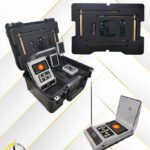
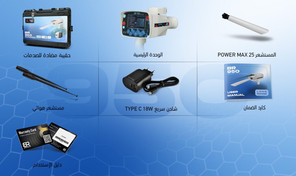
A hard plastic bag of 2 anti-dust and reinforced with reinforced sponge to save the device.
Geophysical Imaging Search System
Geophysical Imaging Search System
This system, developed exclusively by BR Systems, utilizes a new technology for measuring soil electrical resistivity (SRT) to locate and detect underground water. The system has been fully updated to enable highly accurate water detection, displaying results instantly on the screen. This new technology also displays a 3D image of the detected scan, allowing us to gain complete details about the detected location. The scan is then automatically stored in the device's memory.
Distinguishing between types of detected water: This system automatically displays the type of water detected after the search is complete, displaying (fresh water, mineral water, salt water, or highly saline water) on the screen.
3D Mapping of the Target: This system displays a 3D illustrative image of the target. The image of the detected target can be moved in several directions to verify its size.
This device is equipped with an external application installed on a tablet computer, through which we can view the full search results, as well as create a 3D map of the targets and store them directly. The tablet and the device are connected automatically (without the need for an internet connection) via the device's Wi-Fi network (called BR 950 PRO - password: brsystems). We open the application and review the results.
This device is equipped with an external application installed on a tablet computer, through which we can view the full search results, as well as create a 3D map of the targets and store them directly. The tablet and the device are connected automatically (without the need for an internet connection) via the device's Wi-Fi network (called BR 950 PRO - password: brsystems). We open the application and review the results.
Display digital indicators that interact with all captured signals.
Display interactive audio indicators at all times when a search is running, starting, and ending, with the ability to adjust and change them.
Displaying the percentage of water salinity detected through the newly developed scientific PPM analysis technology.
Choose the type of soil to be detected before starting the search.
Changing the frequency of the HZ signal, this feature allows for greater effectiveness and detection power in hard and dry lands when the signal is increased and can be raised from 30 HZ to 150 HZ.
Select the type of soil to be examined before starting the search.
Adjust sensitivity: The sensitivity of the transmitted signal can be increased to increase the transmission of the electrical signal in the soil using special values displayed on the screen. These values can be increased or decreased according to the density of the water to be detected.
Automatically determining the distance between the search poles (from 5 m to 50 m) is a new feature in the world of geophysical devices for water detection. The distance between the search poles can be determined through the device software before starting the search to match the actual distance used on the ground by the user. This feature ensures more accurate results than traditional methods.
Geophysical Search System (Quick Search)
Geophysical Search System (Quick Search)
This system operates using SRT technology developed by BR Systems, which probes and measures the electrical resistivity of the soil to locate and detect underground water.
The Quick Scan system performs rapid scanning within a narrow area by implanting only two electrodes in the soil, eliminating the need for four electrodes.
After connecting two electrodes in the soil, we select the search line that corresponds to these electrodes. For example, search line A corresponds to electrodes 1 and 2. The device will scan only within this line and display the results on the screen. This feature can be used when a quick scan is needed in a narrow space, or after using the automatic search system to limit the location of water within 1 m².
- Distinguishing between the types of detected water. This system automatically displays the type of water detected after the search is complete, and it appears on the screen (fresh water, mineral water, salt water, or highly saline).
- Maximum search depth: 1,200 meters below the ground surface.
- Automatically determines the water propulsion force on the screen using a special indicator and a percentage (Rate%).
- Displays digital indicators that interact with all captured signals.
- Displays interactive audio indicators continuously during operation, as well as when the search begins and ends, with the ability to adjust and change them.
- Displays the salinity of the detected water using the newly developed scientific PPM analysis technology.
- Determines the depth of the detected water on the screen, which appears automatically on the display after the search is complete.
Geophysical Search System (Automatic Search)
Geophysical Search System (Automatic Search)
The automatic search system in this device has been developed and integrated with modern technologies and software to enable high-speed detection and provide detailed automatic results on the screen for water locations, density, depth, and salinity.
Using this system, we can conduct a comprehensive search of a specific area by attaching four electrodes to the soil and connecting them to the device via special connection cables.
This system displays the search results directly on the screen after the scanning process is complete. It provides a detailed report of the scanned area, showing the location of water, accurately identifying the target within 1 m².
The scanning process in this system is carried out along six different scanning lines: A, B, C, D, E, and F.
Distinguishing between the types of water discovered: This system automatically displays the type of water discovered after the search process is complete, and the screen displays the following: (fresh water, mineral water, salt water, highly saline water).
Maximum search depth: 1200 meters below the ground surface.
This device is provided with an external application installed on a tablet computer, through which we can view the search results in full, in addition to a 3D drawing of the targets and store them directly, and the connection between the tablet and the device is done through the Wi-Fi network (called BR 950 Profissional-Password: brsystems) of the device automatically. (Without the need for the Internet), we open the application and review the results.
Display digital indicators that interact with all captured signals.
Automatically determines the water pressure on the screen using a special indicator and a percentage.
Displaying the percentage of water salinity detected through the newly developed scientific PPM analysis technology.
Displays digital indicators that interact with all detected signals.
Long-Range Detection System
Long-Range Detection System
For the past ten years, B-Archistems has been developing and updating its Long Range Locator detection systems, developing the best and most effective technologies for detecting groundwater. This has been achieved through continuous field testing, ensuring that its products are always at the forefront and most widely used by prospectors around the world.
The horizontal sensing technology (Long Range Locator) in the BR 950 is based on scientific principles and modern technologies recently developed and designed by BR Systems. It is characterized by its high accuracy and efficiency in detecting potential targets in the surrounding area in a short time. With this system, you can select the type of water you want to detect (fresh water, mineral water, salt water, or all types of water), and the device will automatically direct you to the strongest water points in the area, leading you to the target center in record time.
This system features rapid target tracking from distances of up to 2,000 meters, achieving high capture accuracy and accurate targeting. It can also operate in all types of terrain and on all types of soil, whether arid or humid.
New BRF Signal Filtering Technology:
This device is equipped with a new BRF signal filtering technology to maintain a clear and accurate signal, free from interference from ground radiation emanating from rocks and natural mineral interference in the soil. This technology can adapt to the soil and identify its mineral content with great precision, enabling the device to pinpoint the real targets in the area with great accuracy and avoid any mineralization or radiation present therein. This also enables the device to be used in all rugged areas and various terrains at all times.
Long-Range Search System Features:
The ability to determine the type of water to be detected before starting the search and restrict other types of water.
The device reaches a depth of 950 meters underground, with the ability to specify the maximum depth required.
The maximum search range is 2,000 circular meters, with the ability to locate at multiple levels.
This device is supported by B.U.M. Automatic Monitoring Technology.
The system supports on-screen radar signals indicating that the system is in use and operational.
The system supports on-screen audio for radar signals.
G.L.Y. guidance laser technology has been added to the system, which shows the user the direction of the target and guides them to it until they reach the target center.
The ability to change the frequency from -25 Hz to +25 Hz is more beneficial for users who have been using the device for a longer period of time.
The list of targets the system detects includes: fresh water, mineral water, salt water, and all types of water simultaneously.
The ability to control the required maximum depth from 25 m to 950 m, based on the user's preference.
The ability to control the forward detection range from 100 m to 2,000 m, based on the user's preference.


Reviews
Clear filtersThere are no reviews yet.